Data From The Sky
How AI’s next frontier is reshaping the geospatial industry
Geospatial intelligence is entering a new era. The convergence of artificial intelligence and Earth Observation is rewriting who gets to see the planet, how often, and at what cost.
There are now 16,019 active satellites in orbit as of June 15, 2026.”. And many more are planned. Together they generate terabytes of Earth data daily, covering climate, infrastructure, biodiversity and land use.
Data alone is not enough. AI has become the layer that turns pixels into decisions. Advances in machine learning, cloud computing and accessible tooling have collapsed the barriers to entry. A broader set of actors now hold intelligence that was once the preserve of states and defence primes. The discipline emerging at this intersection is GeoAI.
The applications are already commercial:
- Climate risk modelling and disaster response
- Urban planning, infrastructure monitoring and land use optimisation
- ESG reporting and supply chain transparency
- Precision agriculture and food security
Synthetic geospatial data is accelerating all of it. AI-generated datasets fill coverage gaps, cut cost, and simulate rare or extreme scenarios that no archive contains. The value is enormous. So are the open questions around reliability, ethics and governance.
VC insight. Synthetic geospatial data is creating a new investable layer at the intersection of space, AI and critical infrastructure. As software eats spatial data, a wave of platforms is emerging: highly scalable, API-first, and positioned to power the next generation of global intelligence.
Why Now
Earth Observation has moved from a state-led, hardware-heavy domain into one of the fastest-growing markets for private innovation. Climate monitoring, supply chain oversight, agriculture, insurance and defence all now depend on it.
Space Foundation reported that the global space economy reached $613 billion in 2024, up from $570 billion in 2023.
Climate resilience, environmental compliance, urban planning, logistics and disaster prevention are driving the urgency.
The infrastructure has not kept pace. Legacy satellite imagery still carries structural limits:
- High cost for high-resolution data
- Sparse coverage in remote and low-priority regions
- Latency of 24 hours or more between capture and usability
- Almost no data for rare or unpredictable events
Coverage is also spatially biased toward the Global North, and formats remain inconsistent between providers. Revisit rates, cloud interference and narrow fields of view compound the problem.
Meanwhile the regulatory floor keeps rising. The EU Green Deal, Net Zero mandates and the US IRA have made EO usage effectively mandatory across infrastructure and climate applications. Demand surged again after COVID, the war in Ukraine, and each successive climate shock.
The market needs a programmable data layer. Raw pixels are no longer the product. Decision-ready analytics are.
The Data You Cannot See
Synthetic geospatial data is artificial data generated from original data, produced by a model trained to reproduce the source’s statistical characteristics and structure. It matters most where real data is limited, expensive, or sensitive.
Providers like MOSTLY AI and Another Earth have made generation accessible to anyone with a dataset and a connection (Romano, 2025). The synthetic data generation market is projected to grow sharply across sectors.
Generative AI meets Earth Observation
Generative AI creates outputs by processing input data, influencing both physical and virtual environments. Public attention arrived with ChatGPT in November 2022. The underlying model advances have not slowed since.
The relevant capability here is physically accurate synthetic data: outputs that emulate the distribution and nature of pixels from real sensor collections, including raw data from complex instruments like synthetic aperture radar (AI for Good, 2024). That allows hyperrealistic environments to be built inside training sets.
Satellite data, 3D rendering, AI and advanced computing combine to enable three things legacy EO cannot (Dalton, 2024):
Continuous generation in under-mapped regions. Synthetic data fills the tails of distributions where real coverage is scarce. Models can be pre-trained for satellites that are not yet in orbit (Romano, 2025).
Faster model training and simulation. Synthetic data provides a sandbox for testing and research without exposing sensitive information, and generates the extreme cases real archives have never captured (Romano, 2025).
Zero-latency monitoring of critical infrastructure. SAR imagery delivers reliable monitoring day or night, cloud or clear, detecting surface change on bridges, dams and pipelines at millimetre accuracy. In security and disaster management, that speed is the product (Gomes, 2026).
What synthetic data solves
Cost. It removes the labelling burden on large imagery datasets, the single largest line item in most computer vision pipelines.
Bias and diversity. Where real training data is scarce or skewed, synthetic data allows deliberate construction of balanced datasets (Romano, 2025). This is the precondition for generalist foundation models in geospatial. Synthetic data can inherit source bias, but datasets can be adjusted to correct it.
Repeatability for rare-event simulations. Rare and dangerous scenarios can be simulated at will, from extreme weather to fraud patterns to conditions no sensor has yet observed (Romano, 2025).
Where it is being deployed
Climate tech. Monitoring greenhouse gas emissions across supply chains, assessing extreme weather risk, and prioritising environmental upgrades (Dalton, 2024). Xoople is building Earth intelligence for physical surface change. Reask applies AI to extreme weather forecasting with probabilistic hazard maps and stochastic event catalogues.
Insurance. AI is automating underwriting and claims across the value chain. Satellite data has been used in agricultural insurance for harvest estimation and post-event loss intensity for years. Predictive analytics now refines pricing on natural catastrophe exposure.
Mobility. Synthetic data trains and tests autonomous systems against complex scenarios. Satellite-enabled positioning, navigation and timing underpins fleet management, supply chain visibility and autonomous vehicles.
And other sectors. Urban planning, health, real estate, precision agriculture, pest and disease identification, environmental degradation monitoring, and AI-powered carbon accounting for sustainability reporting.
Synthetic Geospatial Data: Market And Sector Map
The global geospatial analytics market was valued at $85.5 billion in 2023 and is estimated to reach $220.2 billion by 2033, growing at a 9.6% CAGR (INC, 2025) (Correa, 2025). The EO data and services markets topped $4.6 billion in 2021 (ELMASRY, 2022) and are set to reach $7.9 billion by 2031 (SpaceWatch.GLOBAL, 2022).
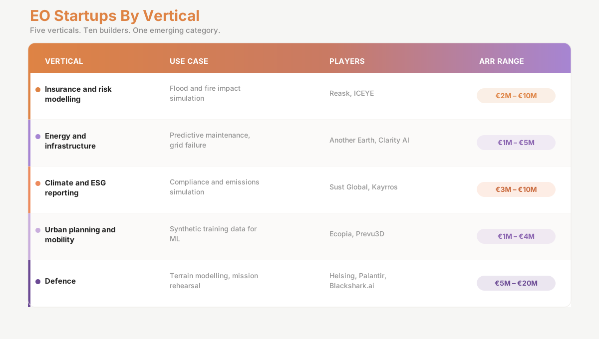
Five verticals are being unlocked: defence and ISR, risk modelling and insurance, urban planning and smart cities, ESG compliance, and climate resilience.
Proof In The Field
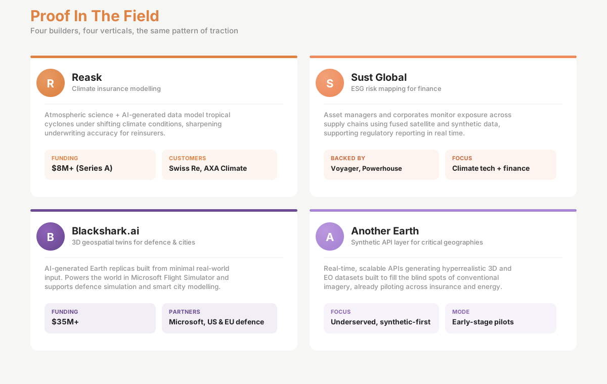
Reask. Climate insurance modelling. Reask combines atmospheric science with AI-generated data to model tropical cyclones under changing climate conditions. Its models are used by reinsurers including Swiss Re to improve underwriting accuracy and anticipate loss in underserved markets.
➤ Funding: $8M+ (Series A) | Customers: Swiss Re, AXA Climate
Sust Global. ESG risk mapping for finance. Asset managers and corporates monitor exposure across supply chains and infrastructure portfolios using fused satellite and synthetic datasets. The platform supports regulatory reporting and real-time climate risk analysis.
➤ Funding: Backed by Voyager Ventures, Powerhouse | Focus: Climate tech + finance
Blackshark.ai. 3D geospatial twins for defence and urban planning. The company builds AI-generated Earth replicas from minimal real-world input. Its technology powers the world in Microsoft Flight Simulator and supports defence simulation and smart city modelling.
Funding: $35M+. Partners: Microsoft, US and EU defence clients.
Another Earth. Synthetic API layer for critical geographies. Real-time, scalable APIs generating hyperrealistic 3D and EO datasets designed to fill the blind spots of conventional imagery. Already in pilot across insurance and energy for model training and predictive analytics.
➤ Focus: Underserved zones, synthetic-first infrastructure | Mode: Early-stage pilot deployments
Across all four the outcome pattern is consistent: faster model convergence, lower cost of inference, and sharper insight in high-risk or data-poor environments.
Operators On The Record
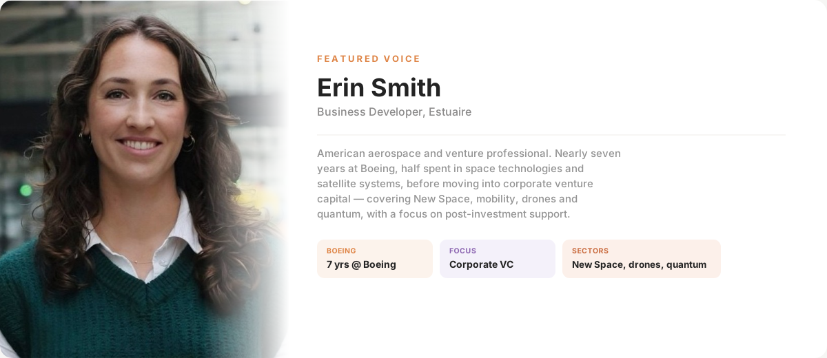
Erin Smith is an American aerospace and venture professional, currently working at Estuaire as a Business Developer. Nearly seven years at Boeing, half of it in space technologies and satellite systems. Later moved into corporate venture capital, covering New Space, mobility, drones and quantum, with a focus on post-investment support.
1. How do you see the current evolution of the geospatial AI market?
“There’s this in-between space-between R&D and commercial-which is stuck right now. There’s so much potential, but I’m still trying to find the right entry points. What’s promising is the possibility to build on top of hardware with software layers that make this data usable. That’s where I see change happening.”
2. What use cases do you find the most promising for synthetic geospatial data?
I think these things are fun, and I miss working on them. I used to explore these use cases in other domains. It’s really about giving breathing room for experimentation. There’s value in going back into some of these older domains and seeing what synthetic data can unlock-especially when you abstract from the hardware.
3. Do you think VCs should pay close attention to this space?
Absolutely. There’s a lot of untapped potential. The opportunity lies in decoupling data collection from hardware dependency. Software-first platforms built on synthetic data are highly scalable.
4. What types of clients do you see in this market?
It depends. But from what I’ve seen, it’s governments, emergency response platforms, urban planning teams, or even climate startups. The use cases tend to require niche insights, but with a strong need for interoperability.
5. What exit opportunities could you envision for VCs in this space?
Hmm… I’m not sure I can speak to that precisely. But I think if you build something that makes hardware abstract and the data interoperable and actionable, you’ve created a layer that bigger platforms or governments would want to acquire.
Maya Pindeus
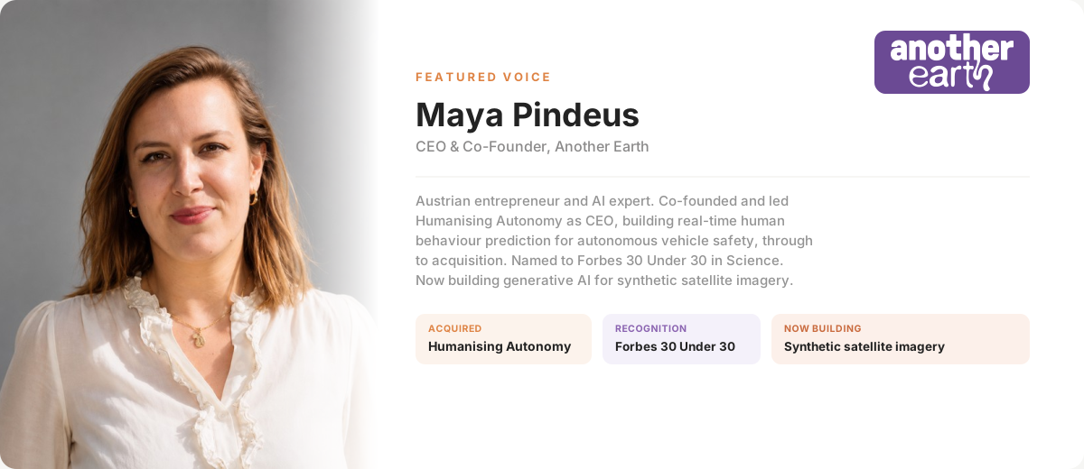
Maya Pindeus is an Austrian entrepreneur and AI expert. Co-founder and former CEO of Humanising Autonomy, acquired after building real-time human behaviour prediction for autonomous vehicle safety. Recognized in Forbes 30 Under 30 in Science, Maya is now CEO & Co-Founder of Another Earth, building generative AI solutions to create synthetic satellite imagery for scalable environmental AI applications.
1. What are the most promising use cases for synthetic Earth Observation data, and where is it already delivering value today?
Synthetic Earth Observation data is already delivering value in areas prone to risk, with high frequency of changes and where real data is limited, delayed, or too sparse – such as simulating climate risks (wildfires, floods), monitoring critical infrastructure, and training AI models on rare or future scenarios.
It’s especially promising for insurance, energy, oil and gas, commodity markets, ESG reporting, and climate adaptation planning.
At Another Earth we are seeing traction in two areas:
- Raw Materials and Mining, where synthetic data helps train models to predict structural changes of mines and the risk levels / ESG impact of large mining projects.
- Climate Adaptation, where synthetic data helps train models to provide assessments and predictions around vegetation, such as biomass, carbon footprint, species identification and health.
2. Which industries (e.g. insurance, energy, defense) show the strongest adoption signals for synthetic Earth Observation?
We see strong adoption signals in parametrical insurance and reinsurance (for risk modeling and event simulation), energy and mining (for asset monitoring and environmental compliance), and defense and security (for rare object and activity detection). These sectors already rely on EO but face data gaps that synthetic data can fill.
3. Data & Integration Challenges – What poses the greatest challenge: training data quality, latency, regulatory push-back in terms of AI and Earth Observation?
By far the biggest challenge that AI in Earth Observation is facing is training data quality – training data accounts for 90% of the quality of an AI model. This is where Synthetic data really adds value. With Synthetic data we can ensure that the data generated is unbiased. realistic, diverse, and truly useful for model training or scenario simulation.
Regulatory push-back on synthetic EO data is minimal so far, but explainability and validation remain key for AI in general and also for enterprise adoption.
4. Market landscape – How do you see the competition between pure satellite datasets and synthetic data layers?
Synthetic data acts as an enabler, as a force multiplier for real satellite data. There is no competition, but it simply provides the necessary tools required to turn satellite data into powerful AI based insights, to simulate rare events, and enable preemptive modeling. The future is hybrid: synthetic data and real satellite data will be combined to build more resilient AI and analytics pipelines.
5. Tech Evolution: From your experience, how mature and accurate are synthetic data models when compared to real EO data?
From our experience at Another Earth, benchmarking synthetic Earth Observation data against real satellite imagery has shown that synthetic datasets can achieve equal or higher model performance in key use cases. In many cases, synthetic data not only matches real EO but provides additional advantages: it comes with rich, pixel-perfect labels that real satellite data rarely offers, enabling faster and more accurate model training. Synthetic data also allows us to easily incorporate rare events, edge cases, and underrepresented geographies, creating diverse and unbiased datasets that are difficult or impossible to source from historical satellite archives. This makes synthetic EO not just an alternative, but a powerful complement that helps close the most critical data gaps in Earth Observation.
The Inovexus view from Philippe Roche
Why now? There is a structural bottleneck in geospatial AI: the lack of high-quality, annotated satellite data. Synthetic data solves it with pixel-perfect, customisable imagery for AI training. Demand across sectors is growing fast.
The core benefit. Fully controllable, perfectly labelled, built for AI models. It removes the cost of real-world collection and annotation, and it travels across climate, infrastructure and defence.
The commercial shape. Synthetic data delivered via API becomes foundational infrastructure. Climate, insurance, infrastructure and defence are already showing traction.
What we back. Technical defensibility, capital efficiency, cross-industry relevance. Teams who build from scratch, own their stack, and show early market traction.
Prototype to Series A. Customer interest, integration into real AI pipelines, and signs of repeatable commercial use. Traction is key, not just technology.
What comes next. Generative AI, advanced 3D rendering and simulation converging into the foundation of the next generation of geospatial intelligence.
Where Capital Moves
Synthetic geospatial startups sit at the intersection of space, AI and infrastructure technology. That position carries three structural advantages.
Defensibility. Proprietary rendering engines, custom-trained models and real-time delivery pipelines are hard to replicate and already embedded in enterprise contracts.
Demand. Enterprise and government buyers are both active. Early public institution traction functions as credibility and as de-risking.
Revenue shape. API-driven, recurring, SaaS-like. Predictable ARR and sticky integrations.
Exit paths are visible. Strategic acquirers include Maxar, Palantir, Esri and government buyers. Climate risk platforms and geospatial majors are consolidating. Dual-use govtech opens a second route.
The question is why now rather than five years ago. Compute costs have fallen. AI tooling has matured. Synthetic data has moved from lab to industry.
Signals To Watch
Synthetic and real data fusion. Hybrid pipelines are becoming the default architecture rather than a workaround.
Open API layers. Synthetic data plugging directly into infrastructure and ESG platforms.
Foundation models for spatial data. Generative architectures tailored to Earth Observation rather than adapted from text and image.
3D city twins. Web-native engines like Cesium and Unreal reaching enterprise grade for planning, navigation and simulation.
Standardisation pressure. ISO and OGC level initiatives forming around synthetic EO outputs.
The Entry Window
Synthetic geospatial data is becoming a foundational layer of global infrastructure. It already powers decisions in defence, insurance, ESG compliance and climate resilience.
This is not a space play. It is the rise of synthetic infrastructure: a software-based data layer built on top of real-world geospatial systems. Programmable, API-first, and capable of displacing latency-bound legacy EO.
Three forces are converging.
Public sector validation is accelerating. ESA, NASA and defence ministries are awarding early contracts to synthetic data providers.
Regulation has become an accelerant rather than a constraint. The EU Green Deal, US IRA and ESG frameworks require geospatial monitoring that legacy EO alone cannot deliver. ESA, EEA and NOAA are piloting hybrid models for emissions, land use and climate compliance. The World Bank and UN agencies are using synthetic data in disaster resilience programmes across Sub-Saharan Africa and Southeast Asia.
Technical maturity has met demand. AI-native EO stacks and real-time 3D rendering pipelines are in production.
The window is asymmetric.
Valuations remain attractive. Most pre-seed, seed and pre-Series A synthetic EO companies price below AI or climate SaaS equivalents despite comparable addressable markets.
Access remains uneven. The complexity of combining EO, AI, simulation and APIs deters generalist capital. Rounds stay under the radar, often in stealth or dual-use sectors, and lightly contested. Access is relationship-driven. Sector fluency creates leverage on pricing and founder alignment.
Underpriced assets. Strategically exposed markets. A limited window for early positioning.
About Inovexus
Inovexus is a global, community-powered and AI-enhanced capital intelligence platform that brings together investors, founders, mentors and partners. Through trustedrs, collective expertise and curated deal flow, Inovexus turns fragmented signals into informed investment decisions, mobilizes smart capital and helps ambitious early-stage technology founders scale internationally.
Its investment footprint already spans Europe and the United States, with expansion into Asia planned from 2027.
References
Romano, Antonello. ‘Synthetic Geospatial Data and Fake Geography: A Case Study on the Implications of AI-Derived Data in a Data-Intensive Society’. Digital Geography and Society, vol. 8, June 2025, p. 100108. DOI.org (Crossref), https://doi.org/10.1016/j.diggeo.2024.100108.
AI for Good. (2024, March 1). Geospatial Frontiers: Navigating the Future with Generative AI and Foundational Models. YouTube. https://www.youtube.com/watch?v=86iWqJJv_9U
Alvarado Ramírez, R. E., & Rodriguez-Roda Layret, I. (2024). Co-designing the future with generative ai: Cultivating student digital competencies for tomorrow. 7756–7762. https://doi.org/10.21125/iceri.2024.1896
Dalton, A. (2024, April 18). AI + Earth Observation Data Could Catalyze a World’s Worth of Climate Progress. Wall Street Journal. Wall Street Journal.
Reask—Global catastrophe risk data conditioned on today’s climate. (n.d.). Retrieved 30 July 2026, from https://reask.earth/
RenderedAI. (n.d.). Accelerating data engineering for computer vision. YouTube. Retrieved 30 July 2026, from https://www.youtube.com/channel/UCsRhDZYwl0UCd1WIN4Av3xw
The Earth data infrastructure layer built for AI. (n.d.). Xoople. Retrieved 30 July 2026, from https://www.xoople.com/
Correa, D. (2023, February 9). Geospatial analytics market valuation worth usd 209. 47 billion by 2030, at 13. 0% cagr – report by allied market research. EIN Presswire. https://www.einpresswire.com/article/616105713/geospatial-analytics-market-valuation-worth-usd-209-47-billion-by-2030-at-13-0-cagr-report-by-allied-market-research
SpaceWatch.GLOBAL (2022) EUROCONSULT predicts global commercial EO data and services to reach US $7.9 billion by 2031, SpaceWatch.GLOBAL. Available at: https://spacewatch.global/2022/12/euroconsult-predicts-global-commercial-eo-data-and-services-to-reach-us-7-9-billion-by-2031/ (Accessed: 31 July 2026).
Space Foundation Editorial (2024) Space Foundation announces $570B space economy in 2023, driven by steady private and public sector growth, Space Foundation. Available at: https://www.spacefoundation.org/2024/07/18/the-space-report-2024-q2/ (Accessed: 31 July 2026).